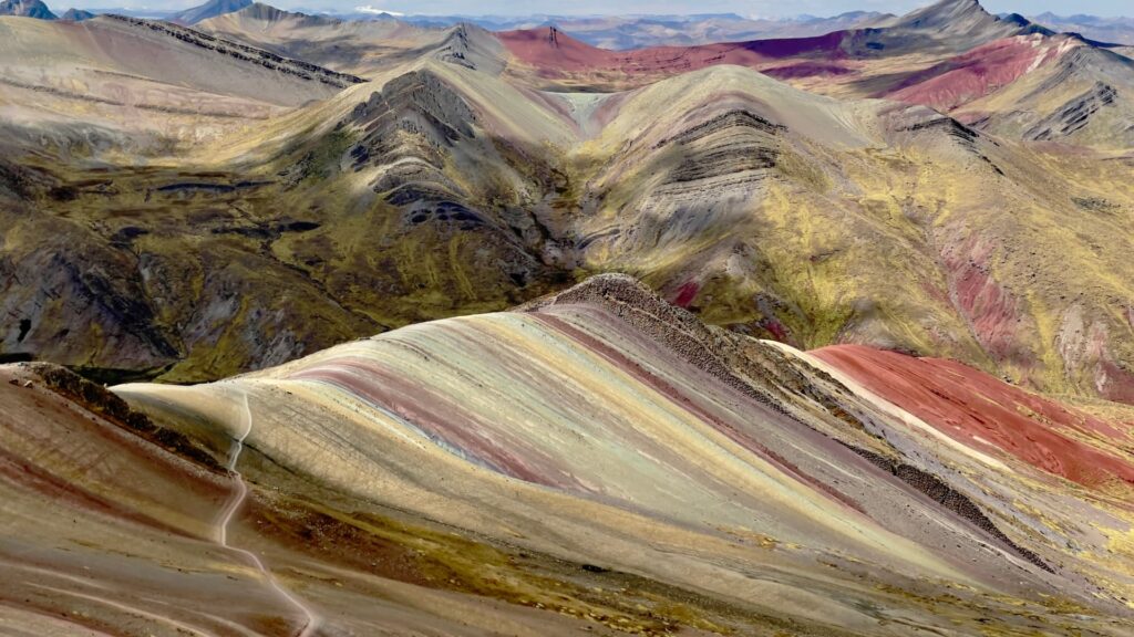

Standing before the multi-colored Andean cordillera does not require enduring an exhausting vertical battle. While Vinicunca draws massive crowds with its punishing climb, palccoyo rainbow mountain offers a tranquil and accessible alternative. Here, travelers explore an entire valley of mineral-striped peaks without the physical exhaustion of steep switchbacks.
Budget day trips often cram travelers into shared mini-vans departing Cusco at 3:00 AM, rushing passengers past scenic valleys and pushing them up narrow paths without medical oversight. For multi-generational families or visitors dealing with early altitude symptoms, that rushed format quickly turns a dream vacation into an overwhelming ordeal.
You deserve an expedition that prioritizes safety, tranquility, and authentic cultural connection. By choosing palcoyo rainbow mountain (often documented under the dual spelling Palccoyo), you trade steep scree scrambles for gentle ridge walks, enjoying panoramic views of three mineral-striped valleys backed by certified wilderness guides and onboard medical oxygen.

1. Location and Geography: Where Is Palccoyo Mountain Located?
Understanding the remote geography of palccoyo cusco ensures you prepare properly for transit times, road conditions, and panoramic Andean vistas.
Regional Setting in Canchis Province
The geological basin of palccoyo mountain lies in the Canchis province of southern Peru, approximately 125 kilometers (78 miles) southeast of Cusco’s historic center. It sits in a high alpine plateau adjacent to the southern skirts of the Vilcanota mountain range.
Unlike the singular ridge of Vinicunca, this area forms part of a broad red-sandstone basin often referred to as the Peru Rainbow Valley, where ancient tectonic uplift exposed multiple layered valleys simultaneously.
Driving Route and Road Transitions from Cusco
Reaching this serene highland valley requires a scenic vehicular route that transitions through distinct Andean environments:
- Southern Valley Highway (Route 3S): A smooth paved two-lane highway heading southeast from Cusco past the historic towns of Urcos and Cusipata toward Combapata (approx. 2 hours).
- Checacupe Colonial Crossing: Vehicles cross the Pitumarca River over an authentic 17th-century Spanish colonial bridge built directly above an ancient Inca suspension bridge foundation.
- Palcoyo Valley Dirt Road: A winding unpaved road gently climbing past Quechua hamlets and grazing herds directly to the trailhead plateau parking lot at 4,900 meters (approx. 1.5 to 2 hours).
Total driving time averages 3.5 to 4 hours each way. Because the road carries vehicles all the way up to the highland plateau, hikers skip the grueling vertical climb required at other high-altitude ridges.
2. Trail Metrics and Physiology: Understanding Palccoyo Altitude
Although the hiking trail is gentle, the extreme palccoyo altitude commands strict physiological respect and careful pacing.
Summit Elevation and Starting Heights
The vehicular parking area for palccoyo mountain peru sits at 4,900 meters (16,076 feet) above sea level. The trail follows an undulating highland crest, terminating at the highest scenic viewpoint and stone forest at 5,000 meters (16,404 feet).
Hikers only gain approximately 100 vertical meters (328 feet) across the entire walk. This minimal elevation gain provides a world of difference compared to Vinicunca’s 600-meter vertical grind.
Unified Hike Duration and Trail Profile
As detailed in our direct comparison of Palcoyo vs Vinicunca, the trail covers just 1.5 kilometers (0.9 miles) one-way, making for an easy 3-kilometer (1.8-mile) round trip.
The walk takes approximately 45 minutes each way at an unhurried, steady pace. The footpath is wide, well-maintained, and features gentle natural gradients with built-in stone resting perches rather than slick dirt switchbacks.
“Palcoyo is the ultimate choice for travelers who want world-class alpine scenery without pushing their cardiovascular limits to exhaustion. Because the trail is largely flat, your body can focus on adapting smoothly to the 4,900-meter atmosphere.”
— Senior Lead Expedition Guide, Qosqo Expeditions
For detailed advice on how extreme heights affect lung capacity across the Vilcanota range, review our complete Rainbow Mountain Guide & Tips.

3. Highlights Beyond the Stripes: The Stone Forest and Ausangate Views
Visiting palcoyo rainbow mountain offers far more than a single painted rock face. The high basin provides a diverse array of geological wonders within a compact walking radius.
What Is the Stone Forest (Bosque de Piedras)?
Towering above the main rainbow ridge lies the Bosque de Piedras, or Stone Forest. This geological marvel features a labyrinth of sharp, needle-like limestone and sandstone pillars soaring 5 to 10 meters into the alpine air.
These dark spires were carved by millions of years of intense frost wedging, high-velocity winds, and seasonal glacial melt. Walking through these stone columns feels like wandering through an open-air stone citadel perched at the top of the Andes.
Glacial Panoramas and Grazing Herds
Looking eastward on clear mornings reveals the glaciated peak of sacred Mount Ausangate (6,384 m / 20,945 ft) piercing the horizon. The surrounding open valleys support hundreds of alpacas and llamas tended by local Quechua families living in stone-walled pastures.

If you wish to explore dramatic red sandstone valleys nearby, check out our in-depth feature on the Red Valley Cusco.
4. Planning Your Expedition: Seasons, Family Travel, and Private Standards
A seamless day in the high Andes requires smart seasonal planning and a clear understanding of comfort requirements.
Is Palcoyo Suitable for Children and Older Travelers?
Yes. Palcoyo is widely regarded as the premier multi-generational alpine trek in the Cusco region. The lack of steep inclines allows active seniors and school-age children (recommended 8 years and older) to experience extreme high altitude safely.
Additionally, because the trail starts right near the panoramic views, any traveler who feels lightheaded or tired can turn back toward the heated private vehicle within 15 to 20 minutes without missing the overall spectacle.
Best Time to Visit
- Dry Season (May to September): Cold, crisp mornings (-2°C to 4°C) with dry dirt trails and vivid blue skies. Ideal for landscape photography.
- Shoulder Season (April and October): Warmer temperatures with fewer visitors and minimal rainfall.
- Rainy Season (November to March): Afternoon rain showers and occasional snow dustings that temporarily whiten the stone forest.
Group Bus Tours vs. Qosqo Expeditions Private Service
| Expedition Standard | Shared Budget Bus Tour | Qosqo Expeditions VIP Private |
|---|---|---|
| Departure Schedule | 03:30 AM (fixed multiple hostel stops) | Flexible Departure (05:30 AM–06:00 AM) |
| Group Dynamic | 20 to 30 shared passengers | 100% Private (Your Travel Circle Only) |
| Medical Equipment | Rarely carried; no medical protocol | Full Oxygen Tanks & Pulse Oximeters |
| Guide Credentials | Standard tour guides | Wilderness First Responder (WFR) Certified |
| Comfort on Dirt Roads | Cramped minivans without suspension comfort | Premium Heated Executive SUVs / Vans |
| Breakfast & Lunch | Crowded buffet halls in rural villages | Gourmet Freshly Prepared Hot Meals |
Experience the colors of the Andes in complete privacy and safety. Book our full-day Palcoyo Rainbow Mountain Tour, or browse our bespoke Peru Multi-Day Packages.
5. Frequently Asked Questions (FAQ)
Where is Palcoyo located?
Palcoyo is located in the Canchis province of the Cusco department in southern Peru, approximately 125 kilometers southeast of Cusco city near the rural community of Palcoyo and Checacupe.
- Province / Region: Canchis Province, Cusco Department, Peru.
- Highway Route: Highway 3S southward through Combapata, crossing Checacupe.
- Geographical Landmark: Sits south of Mount Ausangate in a high mineral basin.
Check the route on satellite navigation prior to your drive, as unpaved highland roads branch into local sheep tracks.
How high is Palcoyo?
The trailhead parking lot at Palcoyo sits at 4,900 meters (16,076 feet) above sea level, with the highest panoramic viewpoint and stone forest reaching 5,000 meters (16,404 feet).
- Trailhead Altitude: 4,900 meters (16,076 feet).
- Summit Viewpoint: 5,000 meters (16,404 feet).
- Total Elevation Gain: Approximately 100 vertical meters (328 feet).
Acclimate for at least two days in Cusco (3,400 m) before traveling to Palcoyo’s 4,900-meter trailhead.
How long is the hike?
The hike covers a 1.5-kilometer (0.9-mile) trail each way, requiring approximately 40 to 45 minutes of gentle walking to reach the final viewpoint, totaling 1.5 to 2 hours of walking time.
- One-Way Distance: 1.5 kilometers (0.9 miles).
- Round-Trip Distance: 3.0 kilometers (1.8 miles).
- Round-Trip Duration: 1.5 to 2 hours, including ample rest and photo stops.
Maintain a slow, steady breathing rhythm during the gentle uphill walk to keep your pulse steady.
How long is the drive from Cusco?
The drive from Cusco to Palcoyo takes between 3.5 and 4 hours each way, combining two hours of paved highway driving with roughly 1.5 to 2 hours on an unpaved mountain dirt road.
- Highway Segment: 2 hours along Route 3S from Cusco to Combapata.
- Mountain Road Segment: 1.5 to 2 hours along winding unpaved dirt tracks through the valley.
- Total Transit: 7 to 8 hours of total round-trip driving time.
Opt for private executive transport with reinforced suspension to ensure comfort along the unpaved stretch.
Is it suitable for children or older travelers?
Yes, Palcoyo is the most suitable rainbow mountain trek for children and senior hikers due to its short trail length, flat terrain, and immediate proximity to panoramic viewpoints.
- Gentle Gradient: Completely avoids the steep, slippery slopes typical of Vinicunca.
- Fast Views: Colorful ridges become visible within the first 10 minutes of walking.
- Safety Margin: The vehicle remains within a short 20-minute walk at all times in case rest is needed.
Ensure younger children and seniors wear warm technical layers, windproof shells, and wool beanies.
What is the stone forest?
The stone forest (Bosque de Piedras) is a natural geological formation consisting of dozens of towering, jagged rock spires created by millions of years of wind erosion and ice fracturing.
- Rock Composition: Weathered sandstone and limestone pillars measuring 5 to 10 meters tall.
- Trail Position: Located along the ridge just beyond the second rainbow mountain viewpoint.
- Panoramic Value: Offers natural 360-degree viewpoints over the red valley and Ausangate glacier.
Wear sturdy hiking footwear with firm ankle support when walking around loose stones near the rock towers.
Are horse rentals available at Palcoyo?
Horse rentals are generally unnecessary at Palcoyo because of the short, gentle trail profile. While local villagers occasionally have a few horses available, they are not systematically rented out like at Vinicunca.
- Low Demand: Over 95% of visitors complete the flat 45-minute stroll on foot without assistance.
- Occasional Availability: Community members may offer rides for S/ 70 to S/ 90 Soles if requested.
- Trail Friendliness: Frequent stone benches provide natural spots to catch your breath along the path.
Take short, deliberate strides and carry trekking poles rather than relying on horse hire.
What is the entrance fee for Palcoyo?
The local community of Palcoyo charges an entrance fee of S/ 20.00 Soles (approx. $5.50 USD) for foreign travelers, paid at a rural checkpoint booth along the access road.
- Foreign Visitors: S/ 20.00 Soles per person.
- Peruvian Nationals: S/ 10.00 Soles per person.
- Payment Method: Physical Peruvian Soles in cash; credit cards and apps are not accepted.
Carry exact cash in small bills, as remote checkpoint guards cannot break 100-Sol notes.
What bathroom facilities exist at Palcoyo?
Rustic, community-managed restroom facilities are available only at the trailhead parking area. There are no restrooms or shelters along the 1.5-kilometer trail.
- Location: Adjacent to the ticket booth and trailhead parking platform.
- Facility Standard: Basic dry-flush or bucket toilets; expect modest rural infrastructure.
- Access Cost: Usually S/ 1.00 to S/ 2.00 Soles paid in coins to the local attendant.
Pack a personal travel pack of tissues and hand sanitizer in your daypack before departing your hotel.
Can I visit the Checacupe colonial bridge on the way?
Yes. Every tour heading to Palcoyo passes through the historic town of Checacupe, making it an easy and rewarding 15-minute stop along the travel route.
- Three Historic Bridges: The town displays an Inca suspension bridge, a 17th-century Spanish colonial stone bridge, and a 19th-century republican iron bridge.
- Bridge Crossing: Visitors can walk across the restored colonial stone arch bridge over the Pitumarca River.
- Local Admission: A minor S/ 2.00 to S/ 3.00 Sol cash community fee applies to step onto the historic bridges.
Pause at Checacupe on the morning drive toward Palcoyo to stretch your legs and enjoy a glimpse of colonial history.