

Inca Trail altitude is one of the most important factors you need to know before embarking on this famous trek to Machu Picchu. Along the route, you’ll pass through different ecological zones, with steep ascents, mountain passes, and long descents.
On the 4-day Classic Inca Trail, you’ll reach the highest point at Warmiwañusca, at 13,829 feet / 4,215 m, on the second day. Additionally, you’ll cover approximately 8,225 feet / 2,507 m of elevation gain and 9,635 feet / 2,937 m of elevation loss over the entire route.
Knowing these elevation changes will help you understand how demanding each day is and better prepare for the trek. Below, we’ll review the altitude and elevation gain/loss of the Inca Trail day by day, as well as the differences compared to the 2-day Short Inca Trail.
What is the highest elevation on the Classic Inca Trail?
The highest elevation on the Classic Inca Trail is 13,829 feet / 4,215 m, at Warmiwañusca, known as the Dead Woman’s Pass. This is reached on the second day of the trek.
To put this into perspective, Machu Picchu is located at approximately 7,972 feet / 2,430 m, nearly 1,800 meters below the highest point of the trek.
The combination of altitude, steepness, and physical exertion makes this section one of the most challenging parts of the Inca Trail.
Note:
- Elevation is the height of a point above sea level.
- Elevation gain, on the other hand, indicates how much you ascend or descend during the hike.
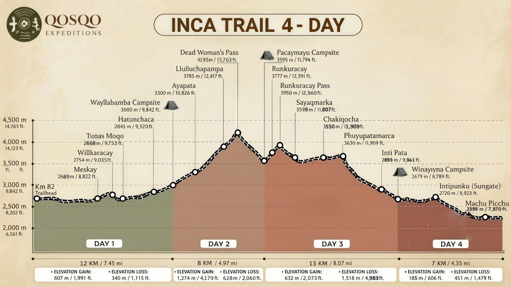
Elevation Gain on the Classic Inca Trail by Day
The elevation profile changes considerably over the four days. The second day features the greatest ascent, while the third day presents a significant combination of ascents and descents.
| Day | Route | Distance | Elevation Gain | Elevation Loss | Duration |
| Day 1 | Km 82 – Wayllabamba | 12 km / 7,45 miles | 1.991 feet / 607 m | 1.115 feet / 340 m | 5–6 h |
| Day 2 | Wayllabamba – Warmiwañusca – Pacaymayo | 8 km / 4,97 miles | 4.179 feet / 1.274 m | 2.060 feet / 628 m | 7–8 h |
| Day 3 | Pacaymayo – Chaquicocha – Wiñay Wayna | 13 km / 8,07 miles | 2.073 feet / 632 m | 4.980 feet / 1.518 m | 8–9 h |
| Day 4 | Wiñay Wayna – Inti Punku Machu Picchu | 7 km / 4,34 miles | 606 feet / 185 m | 1.479 feet / 451 m | 2–3 h |
Day 1: Cusco – Piskacucho – Km 82 – Wayllabamba
The first day begins with the transfer from Cusco to Piskacucho, at Km 82, the starting point of the Inca Trail. From there, the hike to Wayllabamba begins, passing through Miskay and the archaeological site of Patallacta or Llactapata.
Day 1 Details
- Distance: 12 km / 7.45 miles.
- Elevation gain: 1,991 feet / 607 m.
- Elevation loss: 1,115 feet / 340 m.
- Duration: Approximately 5–6 hours.
- Start: Km 82, at 8,717 feet / 2,657 m.
- End: Wayllabamba, at 9,842 feet / 3,000 m.
Day 2: Wayllabamba – Warmiwañusca – Pacaymayo
The second day of the Inca Trail is one of the most challenging on the route. From Wayllabamba, the trail ascends to Warmiwañusca, or Paso de la Mujer Muerta (Dead Woman’s Pass), the highest point on the Inca Trail, at 13,763 feet above sea level / 4,195 m.
Then, the descent to Pacaymayo begins, passing through different ecological zones and offering breathtaking mountain scenery.
Day 2 Details
- Distance: 8 km / 4.97 miles.
- Elevation gain: 4,179 feet / 1,274 m.
- Elevation loss: 2,060 feet / 628 m.
- Duration: Approximately 7–8 hours.
- Start: Wayllabamba, at 9,842 feet / 3,000 m.
- Highest point: Warmiwañusca, at 13,829 feet / 4,215 m.
- End: Pacaymayo, at 11,794 feet / 3,595 m.
Day 3: Pacaymayo – Chaquicocha – Wiñay Wayna
The third day combines ascents and descents and allows you to explore important archaeological sites such as Runkurakay, Sayacmarca, Phuyupatamarca, and Wiñay Wayna.
The route passes through the Runkurakay Pass, located at approximately 3,950 m / 12,959 ft above sea level.
Day 3 Details
- Distance: 13 km / 8.07 miles.
- Elevation gain: 2,073 ft / 632 m.
- Elevation loss: 4,980 feet / 1,518 m.
- Duration: Approximately 8–9 hours.
- Start: Pacaymayo, at 11,794 feet / 3,595 m.
- End: Wiñay Wayna, at 8,789 feet / 2,679 m.
Day 4: Wiñay Wayna – Machu Picchu
The final day begins at Wiñay Wayna and continues toward Inti Punku, or the Gate of the Sun, where you’ll enjoy a panoramic view of Machu Picchu before continuing on to the citadel.
Day 4 Details
- Distance: 7 km / 4.34 miles.
- Elevation gain: 606 feet / 185 m.
- Elevation loss: 1,479 feet / 451 m.
- Duration: Approximately 2–3 hours.
- Start: Wiñay Wayna, at 8,789 feet / 2,679 m.
- End: Machu Picchu, at 7,972 feet / 2,430 m.
What is the most difficult day on the Inca Trail?
The second day is usually the most challenging on the Classic Inca Trail, due to the ascent from Wayllabamba, at 9,842 feet / 3,000 m, to Warmiwañusca, at 13,763 feet / 4,195 m.
On this day, you’ll climb approximately 4,179 feet / 1,274 m, in addition to the subsequent descent to Pacaymayo.
2-Day Short Inlca Trail: Altitude and Elevation Gain
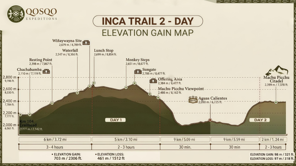
The 2-Day Short Inca Trail has a different elevation profile than the Classic Route.
This route begins at Km 104 and does not pass through Warmiwañusca. As a result, it avoids the ascent to 13,763 feet / 4,195 m on the Classic Inca Trail.
The highest point on this route is 8,924 feet above sea level / 2,720 m, at the Inti Punku – Puerta del Sol archaeological site.
The route includes archaeological sites such as Wiñay Wayna, before continuing on to Inti Punku and Machu Picchu.
In terms of cumulative elevation gain and loss, the Short Inca Trail features approximately:
- Elevation gain: 2,306 feet / 703 m.
- Elevation loss: 1,512 feet / 461 m.
2-Day Inca Trail vs. 4-Day Inca Trail
| Feature | 2 Day Inca Trail | 4 Day Inca Trail |
| Start | Km 104 | Km 82 |
| Duration | 2 days / 1 night | 4 days / 3 nights |
| Warmiwañusca | No | Yes |
| Maximum elevation | 8.924 ft / 2.720 m | 13.763 ft / 4.195 m |
| Elevation Gain | 2.306 ft / 703 m | 8.225 ft / 2.507 m |
| Elevation Loss | 1.512 ft / 461 m | 9.635 ft / 2.937 m |
| Distance | Shorter | Approx. 42 km / 26,1 mi |
| Machu Picchu | Yes | Yes |
If you’re looking for a shorter experience and want to avoid the Paso de la Mujer Muerta, the 2-day Inca Trail may be an alternative.
On the other hand, the 4-day Inca Trail offers a more extensive trekking experience, with greater distance, elevation gain, and more archaeological sites along the route.
How to Prepare for the Elevation Gain and Altitude of the Inca Trail?
Proper preparation can help you better handle the trek.
- Acclimatize: Consider spending a few days in Cusco before embarking on the Inca Trail.
- Train on uneven terrain: Walking on slopes and climbing stairs can help prepare your legs.
- Maintain a steady pace: You don’t need to walk fast; pace yourself.
- Practice descending: Downhill sections can also be challenging.
- Listen to your body: If you experience severe symptoms or symptoms that worsen, notify your guide immediately and seek medical attention as needed.
Good physical condition helps you cope with the exertion, but it doesn’t guarantee that you’ll be free from the effects of altitude.
Is the altitude on the Inca Trail a problem?
Altitude is one of the main challenges of the Classic Inca Trail, especially on the second day and during the ascent to Warmiwañusca. However, much of the route is below 4,000 m / 13,123 feet and ends at Machu Picchu, at 6,693 feet / 2,430 m.
Arriving in Cusco already acclimated, training beforehand, and maintaining a steady pace during the ascents will help you be better prepared to handle the elevation changes along the route.
Would you like to hike the Inca Trail?
At Qosqo Expeditions, we can help you choose between the Classic Inca Trail and the Short Inca Trail based on your schedule and experience.
Contact us and start planning your adventure to Machu Picchu.
Leave a Reply